

Getting around Swanage & Purbeck without a car A Sustainable Swanage guide to active and public transport
Using your car less around Swanage potentially has many benefits. Walking and cycling are good for your health, and public transport saves you money. Fewer cars on the road also means less pollution, and less congestion during the holidays. Overall, it makes it easier to enjoy the outstanding natural beauty of Swanage and Purbeck.

However, Swanage currently has very limited alternatives to car travel:
No dedicated cycleways
No published walking route map
Buses are infrequent, with thin evening services. They also do not sync with mainline rail services
The heritage line doesn't reach the main network
Only one road in and out of town, the A351, which becomes badly congested, especially during the holidays
Consequently, in 2025 there were an estimated 4.2 million motor vehicle journeys* along the A351 alone. The pollution generated included c.13,000 tonnes of carbon dioxide.
Below is a description of the travel options currently available. Following on from that are details of what the Purbeck Transport Action Group, Swanage Town Council and Sustainable Swanage are doing to improve the situation. These include projects you can volunteer to help with.
What's available now
Open any heading to see what runs, when, and what to watch out for.
BusesFour routes from Swanage Station, plus a summer extension
Purbeck Breezer 40
Swanage to Poole, via Langton Matravers, Corfe Castle and Wareham. Runs every day of the year, hourly, from 6.10am (7.10am on Sundays) until 11pm (10pm on Sundays). This is the most useful service for work, appointments and the main line at Wareham.
Purbeck Breezer 50
Swanage to Bournemouth, via Studland, the Sandbanks ferry and Westbourne. Runs every day, half-hourly, from 6.45am to 10.05pm.
Purbeck Breezer 30
Swanage to Wool, Lulworth and Weymouth, via Harmans Cross, Corfe Castle and Wareham. Hourly, from 9.30am to 5.45pm.
Purbeck Breezer 35
Swanage to the Wareham Forest tourist parks, via Harmans Cross, Corfe Castle and Wareham. Four times a day, between 10.25am and 5.30pm.
First Bus X54
Extended from Wareham to Swanage over the summer months, giving a direct service to Lulworth and Weymouth at 12.05pm, 2.05pm, 4.05pm, 6.05pm and 7.15pm.
What it costs
A single adult fare anywhere in England is capped at £3 until the end of 2026, and drops to £2 from January 2027. On the Breezer 40 that covers Swanage all the way to Poole.
Timetables change in late May and again in the autumn, and vary further at different times of day. Evening services are thin, and the 30 and 35 finish much earlier than the 40 and 50.
Community transportNow funded to run every Wednesday, year round
Purbeck Shuttle 200
Run by Dorset Community Transport. Funding is now secured for the 200 to connect Wareham Station with RSPB Arne every Wednesday, all year round.
Over the summer months it also runs on Tuesdays and Saturdays, connecting RSPB Arne with both Wareham Station and Purbeck Park, next to Norden Station on the Swanage Railway.
TrainsHeritage line locally, main line at Wareham
Swanage Railway
Five and a half miles of line from Swanage through Herston Halt, Harmans Cross and Corfe Castle to Norden. There is parking at Purbeck Park next to Norden station.
The gap
The heritage line does not connect to the national network. To reach the main line you need to get to Wareham, and the Breezer 40 is the way to do it. Bus and train times are not coordinated, so you can wait up to an hour for a connection. Joining these up properly is one of the four priorities our survey identified.
From Wareham
South Western Railway runs to Poole, Bournemouth, Southampton and London Waterloo. The Purbeck Community Rail Partnership works on improving the links, and volunteer friends groups look after Wareham and Wool stations. Their new leaflet, Connecting People by Train, is available from Tourist Information centres and libraries.
The Sandbanks ferryThe short way to Poole and Bournemouth
The chain ferry saves a 25 mile road detour via Wareham.
- Runs every 20 minutes, from 7am to 11pm.
- Foot passengers and cyclists pay £1.18. Bikes cross for £1 each way.
- Fully cashless. Vehicle crossings moved to number plate recognition in July 2026.
- Out of service roughly every two years, usually in November, for a full refit.
The ferry is a single point of failure. It was out for nearly four months in 2019 and for 17 weeks over the winter of 2022 to 2023. When it stops there is no walking or cycling alternative at all.
WalkingGood paths out of town, no route map
Where you can walk
Footpaths and bridleways connect Swanage with the villages around it. Priests Way runs west to Worth Matravers. Ballard Down takes you north to Studland. There are paths to Langton Matravers, Harmans Cross and Corfe Castle, and Swanage sits on the South West Coast Path in both directions.
What to expect
Most of these are recreational routes rather than everyday ones. Expect steep climbs, rough ground and mud in winter. Within the town, signage is being improved and more dropped kerbs are going in.
There is no published walking route map for Swanage. Producing one is a job we would like help with, and you'll find it in the volunteering section below.
CyclingNo dedicated cycleways in the town
There are no dedicated cycleways in Swanage.
Getting out of town
The only route out avoiding the main road follows Washpond Lane and Underhill Road to Corfe Castle. It is hilly, and it carries fast traffic on a 60mph limit. National Cycle Route 2 passes through Rempstone, about five kilometres from the town centre, and that section is mostly unsurfaced and floods in wet weather.
Off road
The bridleways over Priests Way, Ballard Down and the ridge from Ulwell to Corfe all offer rewarding riding for confident cyclists. None of them work as everyday transport for most people.
Hiring a bike
Cyclexperience runs a bike hire centre at Purbeck Park, next to Norden station. Mountain bikes and electric bikes are available, with a helmet and toolkit included, and the staff can suggest routes to suit your group. It is usually open six days a week from mid March to October, and by arrangement over the winter. Bikes book up in busy periods, so it is worth reserving ahead.
You can reach Purbeck Park without a car. The Breezer 40 stops nearby and it is the northern terminus of the Swanage Railway.
What we're working on
Three organisations are pushing on this, and they work together rather than separately.
Purbeck Transport Action Group
PTAG is an independent volunteer forum covering the whole Isle of Purbeck, chaired by Nick Ward. It meets roughly every two months and brings together parish and town councils, More Bus, Dorset Council, Swanage Railway, the Community Rail Partnership, the National Trust and residents.
An updated Purbeck Transport Plan
PTAG surveyed residents across Purbeck in spring 2026 and the draft summary is now written. Four priorities came back with strong support: link up walking and cycling routes to public transport hubs, find a workable way to fund local buses, finish the cycle routes already proposed, and join up the railway with feeder buses.
A Swanage circular bus
A local route linking Swanage Station, Durlston and the hospital, and serving the new housing developments. More Bus ran a version of this before and Durlston Country Park confirmed it was well used by residents and missed when it went. The Swanage and Purbeck Development Trust is leading the new plan.
Cycle routes out of Purbeck
Norden to Corfe and Norden to Studland are two of the routes the survey said should be finished first. Dorset Council Highways reported progress in February 2026, though significant obstacles remain. A Norden to Corfe Castle shuttle bus is also the subject of a feasibility study.
Speaking up where the money is decided
PTAG representatives attend the Dorset Bus User Group, which decides how bus grant funding is spent. Members also went to the South West Rural Mobility Workshop, feeding into the Western Gateway transport body. Getting Purbeck's case heard early is worth more than objecting later.

Swanage Town Council
In its Corporate Plan 2026–2030, the Town Council has committed to ‘consider ways to increase cycling and walking across town’. As it is not the highways authority, it works closely with Dorset Council, using its local knowledge to recommend improvements.
Safer streets in town
Signage for pedestrians is being improved and the number of dropped kerbs is increasing. A 20mph limit is proposed for the town centre.
Four practical cycling proposals
A shared pedestrian and cycle path along the north side of the A351, between the B3069 junction and the High Street. It would serve both St Marks and Swanage School. Marked cycle lanes on Northbrook Road and Ulwell Road. And opening up three pedestrian cut-throughs, so people can cross town east to west by bike.
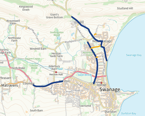
There's real progress towards Studland. The National Trust and Dorset Council are working on a road crossing on Ulwell Road and bank stabilisation nearby, though this now looks likely to slip into 2027. The National Trust is also working with tenant farmers on a new permissive bridleway alongside Ulwell Road, on the inside of the field from the crossing. Together these are a step towards an off-road walking, wheeling and cycling route between Swanage and Studland, alongside the marked cycle lane Swanage Town Council is looking at for the wide part of Ulwell Road.
Sustainable Swanage
We joined PTAG in February 2026, and launched our own Swanage travel and transport group at a public meeting at the Focus Centre in June 2026, with Nick Ward speaking. We focus on Swanage itself and on getting residents involved, while PTAG takes the Purbeck-wide case to Dorset Council.
Building the evidence
Funding for walking and cycling now depends on having proper data. Swanage has none. We are working on a baseline count of how many people currently walk and cycle, and a map showing exactly where people do not feel safe. Without those two things, no bid for money will succeed.
Mapping what's proposed
We have mapped every cycle route proposal for Swanage and Purbeck, so residents and councillors can see the whole picture in one place rather than scattered across meeting papers.
Volunteer with us
Most of what needs doing next costs nothing but time, and none of it needs you to be an expert. Whether you have a little time or a lot, we'd like to hear from you.
Count people walking and cycling
This involves standing at a fix point for an hour recording cycle or pedestrian traffic. The information is an essential element of most funding bids.
Tell us where you don't feel safe
Is there a junction you avoid? A road you would cycle if it felt safer? A school run that worries you? Every location you name makes the case stronger.
Ten minutes, once.
Help make a Swanage walking route map
Swanage has good paths and no map of them. If you know the alleyways, cut-throughs and shortcuts, or you can help with design and printing, we would like to hear from you.
A few hours, and local knowledge.
Come to a PTAG meeting
Meetings are open and you do not need to represent anyone. If you use the buses, walk to work, cycle with your children or struggle to get to a hospital appointment, you know something the group needs to hear. PTAG is also looking for a new secretary.
Roughly every two months, Swanage Town Hall or online.
Tell us what we've missed. Is there a journey you simply cannot make by bus? A footpath that would work for everyday trips with small changes? This page gets better when people who live here add to it.
Elsewhere on this site
Transport is one part of what we do. Sustainable Swanage also runs the Repair Cafe, the Community Pantry, Greening Swanage, Plastic Free Swanage and our energy work.
All our projects · Volunteer with us · Warmer homes and cleaner energy · News and events · hello@sustainableswanage.uk
About this page
We're volunteers and we don't sell anything. We list services that are running now, and we say plainly where something doesn't yet exist. Where Dorset Council, More Bus or Dorset Community Transport already publish good information, we send you to them rather than repeat it.
Timetables and funding change often. Always check before you travel.
* Source: DfT data. A journey means a single passage.