

Our coastal waters are changing fast. We need to protect them.
A Sustainable Swanage guide to what is happening beyond the sand, what is causing it, and what we can do about it.
To the east, Swanage is bordered by the sea. Stand on Peveril Point and look out: Swanage Bay is to your left, Durlston Bay to your right. Below the surface there are four distinct habitats.
Seagrass beds. Meadows of flowering plant rooted in the sand. They shelter young fish and cuttlefish, hold carbon, and take some of the energy out of waves before they reach the shore. Swanage has more of it than anyone realised.
Limestone ledges. The rock that makes Durlston’s cliffs carries on out under the sea, giving wrasse, blennies and lobsters somewhere to live.
The pier legs. Decades of growth on a vertical surface, and the easiest place in Dorset to see it. Divers describe a wall of life.
Sand and gravel. Where the rays, dragonets and flatfish are, alongside ledges, gravel dunes and shipwrecks mapped by the DORIS seabed survey.
The wildlife
Sightings logged over many years by divers, naturalists and conservation groups, and held on the National Biodiversity Network, list around 80 kinds of fish in the waters off Swanage, alongside shellfish, sea slugs, crabs, lobsters and prawns.
Ballan wrasse, tompot blenny, corkwing and goldsinny are the fish divers see most often here, along with pouting, pollack and two kinds of goby. Velvet swimming crab and edible crab lead the crustaceans, with common spider crab and lobster close behind. Cuttlefish, sea hares, sea lemons and two kinds of cowrie are all recorded in the bay. Bigger visitors pass through too: grey seals, bottlenose dolphins, harbour porpoise, and now and then a bluefin tuna, a basking shark or a sunfish.
Nick / dive club, permission needed
What the bay is up against
Human activity, the burning of fossil fuels and the discharge of sewage, is having a negative impact on our coastal waters.
Storms are hitting harder
Storm Ciarán crossed Dorset on 2 November 2023. The National Trust recorded that it gouged away five years’ worth of beach at Studland across two high tides.
Storms now carry more rain, which climate scientists have linked to a warmer atmosphere. And every storm arrives on a higher sea, so the same wind does more damage than it would have done thirty years ago.
The deeper problem is that the beaches cannot replace themselves. Beaches survive because whatever a storm strips away is replaced by sand and shingle arriving from somewhere else, worn off cliffs along the coast or carried in from the seabed. Along much of the Dorset coast that resupply has largely stopped, so what goes is gone.
Beaches here are getting thinner and steeper, and the water just offshore is getting deeper. Deeper water lets bigger waves reach the shore, which takes more beach again.
The cliffs are moving too: 40 landslides have been recorded along the Purbeck coast since the start of 2012, 17 of them since the start of 2023.
Who is dealing with it: Dorset Council is working with residents on an adaptation plan for the stretch of coast that cannot be defended, through Future Coast North Swanage.
Sea levels are rising
Sea levels around the UK have risen about 20cm since 1901. And the pace is picking up. Two thirds of that rise has happened in the last three decades alone.
Why it matters
Higher water does not just move the tideline. It means storm waves arrive at the sea wall in deeper water, so they arrive with more force.
Who is dealing with it: Dorset Council holds the Shoreline Management Plan, which sets what happens to each stretch of this coast over the next hundred years.
Sea temperatures are increasing
Our stretch of the English Channel has now had three summers running of marine heatwave conditions. The Met Office reports the Channel spent much of 2026 in marine heatwave conditions, and that UK waters were in them for more than three quarters of 2025.
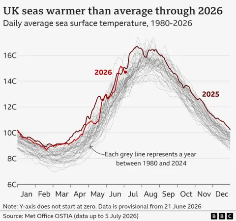
In an interview, the founder of Divers Down, Pete Williams, recalled the sea here reaching about 17°C in summer in the mid 1990s. By the time he retired in 2021 it was over 18°C. In 2026, the sea swimming group is recording temperatures over 20°C.
Why it matters
Warmer water holds less oxygen. It also raises the metabolism of fish and shellfish, so they need more oxygen just when there is less available.
It also changes the ecosystem. Warm-water species are pushing east and north along this coast. Black bream, two-banded sea bream, blackspot bream and comber are all increasing and extending their range.
Who is dealing with it: Nothing, locally. Sea temperature is set globally, so the job here is measuring it rather than managing it. The nearest sea temperature record is a wave buoy in Poole Bay, about fourteen kilometres away. Wessex Water’s new buoy off Peveril Point may change that.
Sewage is polluting the water
There is concern and anger about sewage in our seas and waterways, and this applies to Swanage Bay too.
In the year to September 2023 there were thirteen spills at the Ocean Bay outlet, eight in winter and five in summer, totalling 749 minutes. Signs advising against bathing went up on five days that summer. Pollution forecasts are not issued between October and April, so winter has no equivalent warning.
The problem is storm overflows. When heavy rain overwhelms the sewers, Wessex Water releases diluted sewage into the sea rather than let it back up into houses. Two outlets matter here. Peveril Point is used most and sits further from the beach. Ocean Bay is used less but discharges much closer in, which is why it gets the most attention.
Putting it in perspective, Swanage has held its Blue Flag for more than twenty years. This reflects the fact that the bathing water quality is usually excellent.
What is being done
Swanage Central is a designated bathing water. The Environment Agency samples it weekly from May to September, publishes a daily pollution risk forecast, and gives the beach a classification every November, from Excellent down to Poor.
Wessex Water has committed money from 2025 to cut the use of both the Ocean Bay and Peveril Point outlets. It is also installing a wave buoy off Peveril Point, testing whether the monitoring used at Bournemouth survives in a rough, high-current spot. If it does, we should all get better information about the water we swim in.
Inland matters too. The Swanage Streams Partnership is reducing pollution reaching Swanage Bay by slowing and filtering runoff before it enters Swan Brook.
Holding the water company to account is the first action in the council’s Motion for the Ocean plan.
If you swim in the bay
Check before you go. The Environment Agency publishes a daily pollution risk forecast from May to September, and the Surfers Against Sewage app gives real time alerts when an overflow is spilling. Many regular swimmers simply stay out for a day or two after heavy rain.
Report anything that looks or smells wrong. Call the Environment Agency incident hotline on 0800 80 70 60, and tell us as well so we can follow it up locally.
Turn up and ask. Wessex Water report to the town council in public. Council committee meetings are open to anyone, and the questions swimmers ask carry weight precisely because they are the people in the water.
Who is dealing with it: The Environment Agency regulates Wessex Water and monitors every spill. Wessex Water is cutting the use of both Swanage outlets.
Overfishing has reduced fish numbers
“There are species that we don’t see now. We don’t see the massive shoals of mackerel that you used to, or the big cod or ling, there are not as many cuttlefish as there used to be. And you also don’t see crab or lobsters of any size.”
Pete Williams, who ran Divers Down on Swanage Pier with Pat Collins for some thirty years, speaking on their retirement
He put most of it down to overfishing well beyond local boats.
The wider record backs him. Across the English Channel, cod, haddock and hake fell from 48% of the catch in 1920 to 4% by 2010. Cod and ling declined most sharply of all, and shellfish steadily replaced the fish that had gone.
Bottom trawling and dredging are the blunt end of it. A towed net takes the fish and flattens the seabed they lived on, so the habitat goes with the catch.
Who is dealing with it: Southern IFCA has closed 477.8 square kilometres of Dorset seabed to bottom-towed gear, and can close more where there is evidence.
Protection: who is responsible & what are they doing
Swanage Bay is protected by legislation and various public bodies.
The bay sits at the eastern end of the Purbeck Coast Marine Conservation Zone. It covers 282 square kilometres, running west from Old Harry round the coast to Ringstead Bay, and takes in everything from tide-swept rocky cliffs to sheltered seagrass. Studland Bay Marine Conservation Zone is a separate site immediately north, designated for its seagrass and its seahorses.
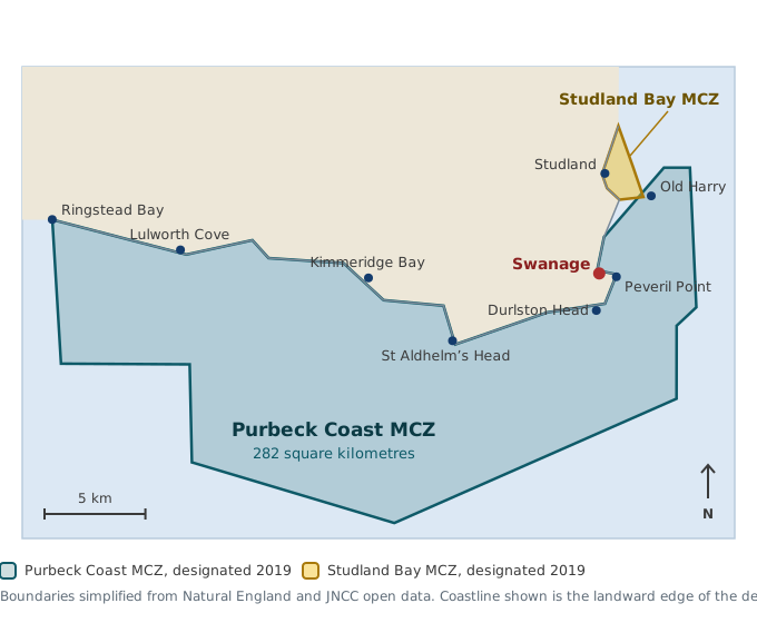
There are five public bodies working to protect our coast and sea. Swanage Town Council is primarily responsible for the beach, which is one of the town’s greatest assets. Other bodies manage erosion, pollution and fishing.
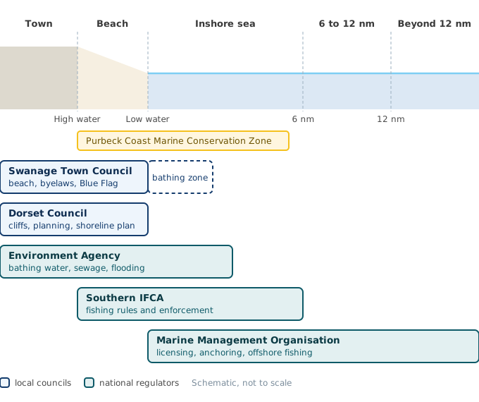
Southern IFCA (Inshore Fisheries and Conservation Authority) Fishing, out to six nautical miles
Under the Marine and Coastal Access Act 2009, the IFCA has to manage fishing sustainably, and to further the conservation objectives of any Marine Conservation Zone in its district. That duty covers fishing only. It makes and enforces its own fishing byelaws and issues permits.
What they are doing. Southern IFCA has closed 477.8 square kilometres of Dorset seabed to bottom-towed gear, patrols the district with vessels, drones and remote cameras, and runs fisheries management plans for the protected sites along this coast.
Talk to them about: trawling, dredging, netting, potting, minimum sizes, spearfishing, hand gathering.
Marine Management Organisation Licensing, planning and anchoring
The national body. It licenses anything built, deposited or dredged in the sea, plans how English waters are used, and manages fishing beyond six nautical miles.
Closer in, it manages what the law calls non-licensable activities inside marine protected areas out to twelve nautical miles. Anchoring is one of them, which makes the MMO relevant to any future conversation about boats and seagrass.
What they are doing. Managing anchoring and other non-licensable activities inside marine protected areas, and assessing where further fishing restrictions are needed. Its byelaw process runs on public consultation, so there is a way in.
Talk to them about: moorings, buoys, anything physically installed in the bay, and anchoring inside the Marine Conservation Zone.
Environment Agency Water quality, and flooding from the sea
The national environmental regulator, and the body most people should be watching on water quality.
It samples designated bathing waters weekly from May to September, publishes a daily pollution risk forecast at many sites, and gives every beach an annual classification from Excellent down to Poor. Swanage Central is one of those designated waters.
It also regulates the water companies, and the storm overflow data it requires them to publish is public.
On top of that it holds the strategic overview of all flooding and coastal erosion risk in England, funds coastal adaptation work, and is already working with the town council on the sea defences between the Pier and the Mowlem.
What they are doing. Sampling Swanage Central weekly through the season, publishing daily pollution risk forecasts, and requiring event duration monitors on every storm overflow. Since January 2025 a dry day spill counts as a pollution incident however small.
Talk to them about: bathing water results, sewage spills, and tidal flood risk.
Dorset Council The cliffs, the shoreline plan and the schools
The unitary authority, and the tier with real statutory weight on the coast.
It is the Coast Protection Authority, which gives it powers, though not a duty, to act on coastal erosion. It is the Lead Local Flood Authority. It is the local planning authority down to the low water mark, where marine licensing takes over. And it holds the Shoreline Management Plan that sets what happens to each stretch of this coast over the next twenty, fifty and hundred years.
Future Coast North Swanage is theirs, funded by the Environment Agency with around £3 million until March 2027. It starts from an uncomfortable premise: in parts of North Swanage, maintaining the sea defences is not sustainable in the long term. Rather than build ever bigger walls, the project is working with residents on an adaptation plan. The National Trust reached the same conclusion at Studland, where it removed the cafe, toilets and sea defences from the undercliff at Middle Beach because the ground beneath them was going into the sea.
Some of this coast can be defended and some of it cannot. Deciding which, in public and in good time, is easier than doing it in a hurry after a storm.
Dorset Council also wrote Dorset’s Local Nature Recovery Strategy, published in December 2025, which sets twelve priorities and maps where action should happen. It runs Durlston Country Park. And it runs the schools, which matters for the Motion for the Ocean pledge that every primary child gets a first-hand experience of the sea.
Talk to them about: cliffs and defences, planning, coastal adaptation, nature recovery funding, and anything involving schools.
Swanage Town Council The beach, and the power to convene
The council’s powers stop at the water’s edge. It runs the beach: cleaning, Blue Flag, beach huts, the designated bathing zone and craft-free area, summer enforcement officers, and the RNLI lifeguard service.
Its byelaws apply on the beach, not in the sea. However, in its Corporate Plan, the council has committed to “developing the Motion for the Ocean to protect Swanage’s Blue Flag beach and Marine Protection Zone”. In effect, this means working with local groups to develop the evidence needed to support further protection measures. The seagrass survey is a good example of this.
What they are doing. Delivering the Motion for the Ocean action plan. Here is what has happened on each commitment.
Scroll sideways to see the progress column.
| Commitment | Progress |
|---|---|
| Report to full council within twelve months on the actions that will begin ocean recovery in Swanage. | Done. The action plan was approved in June 2025, twelve months after the declaration was adopted. |
| Embed ocean recovery in all strategic decisions: plans, budgets, procurement, planning, regeneration and economic policy. | Partial. Folded into the council’s Corporate Plan for 2026 to 2030, adopted in May 2026. No evidence yet on budgets or procurement. |
| Make sure local planning supports ocean recovery, working with the Marine Management Organisation to link the Local Plan and the Marine Plan. | No evidence yet. |
| Make sure nature and climate strategies take a source to sea approach, including the Local Nature Recovery Strategy. | Done. £6,000 funded the Swanage Streams Partnership’s source to sea work on the brook. |
| Work with partners on water quality and a sustainable blue economy, including the local fishing industry and the Inshore Fisheries and Conservation Authorities. | In progress. A water quality information board is up outside the Information Centre, and an autumn event with Wessex Water and the Environment Agency is planned. No evidence yet of work with the fishing industry or IFCAs. |
| Grow ocean literacy, including giving every pupil the chance to experience the ocean first-hand before leaving primary school, and promoting fair access to the sea for all residents. | Partial. The marine bio-audit ran in August 2025 and repeats in 2026, and marine life information signs are funded for 2026 to 2027. The primary school pledge itself, the most concrete promise in the declaration, has no action behind it. |
| Use the council website and other channels to report progress. | Funded, waiting. The Beyond the Sand web platform is deferred to 2026 to 2027. This page is the start of it. |
| Write to government asking it to put the ocean into net recovery by 2030: resourcing the IFCAs properly, appointing a Minister for the Coast, putting ocean literacy in the national curriculum, tightening single-use plastic rules, setting microfibre filter standards for washing machines, and producing a national Ocean Recovery Strategy. | Stalled. The letter has not been written. It has slipped to 2026 to 2027. |
Talk to them about: signage, beach management, grant funding, and getting the right people in a room.
How you can help
Sustainable Swanage
To support the town council with its Motion for the Ocean pledges, Sustainable Swanage has organised a marine-focused community group called Beyond the Sand.
We have several projects in the pipeline and would welcome more volunteers.
- Crabbing education board. Crabbing is one of the few ways a child meets a wild animal up close. Most family crabbing here happens off the seafront wall and at Stone Quay. We are working with the council to install a permanent crabbing information sign there.
- Bio-audit. We ran a successful bio-audit across two weekends in August 2025, logging 282 sightings on iNaturalist. We plan to repeat it for World Ocean Day on 8 June next year.
- The Big Blue Bag. Another educational kit aimed at children, for measuring sea temperature, counting seabirds, and recording coastal debris and microplastics, with identification charts included.
- Public event. We are planning an evening with representatives of the bodies that protect our coastline.
What you can do: help with any of these projects, or just join Beyond the Sand. Email hello@sustainableswanage.uk
Isle of Purbeck Sub Aqua Club
If you dive, take part in the Isle of Purbeck Sub Aqua Club’s project to map the seagrass in the bay.
Seagrass is the richest habitat in the bay and the least understood. It shelters young fish and cuttlefish, holds carbon, and takes some of the energy out of waves before they reach the shore. Until recently nobody had mapped ours.
It does not appear on the national marine database at all. Studland does. Both beds sit inside Marine Conservation Zones designated in 2019, so the difference is where attention and funding went, not the level of protection.
What the survey has found so far
There is far more seagrass than anyone expected. Swimming 200 metres north of the pier and back, the club’s surveyor crossed continuous seagrass, some of it at full cover with fronds 45cm long.
The stretch between the two piers is a different story. It is patchy where it was once continuous, and blackened in a way consistent with seagrass wasting disease. Whether that is boats, disease, or both, nobody has established. Across the southwest, seagrass is actually expanding, which makes our sick patch more interesting, not less.
What we want at the end is a health report, not a campaign. Protection measures follow evidence.
What you can do: visit ipsacdivers.co.uk
Beach Buddies
Beach Buddies clean every Sunday morning and are well supported in summer. Winter is when the storm litter arrives and the volunteers thin out. That is when an extra pair of hands is worth most.
What you can do: visit Swanage Beach Buddies, Litter-free Purbeck and get in touch with them directly.
Tell us what we’ve missed. Seen something unusual in the bay? Have photographs from years back? Know a stretch of shore nobody looks after? This page gets better when people who use the sea add to it.
Elsewhere on this site
The sea is one part of what we do. Sustainable Swanage also runs the Repair Cafe, the Community Pantry, Plastic Free Swanage, our energy work, the nature survey groups and the travel and transport group.
All our projects · Volunteer with us · Waste and recycling · News and events · hello@sustainableswanage.uk
About this page
We’re volunteers and we don’t sell anything. We describe what is happening now, and we say plainly where something is still an intention rather than a project. Where the dive clubs already publish good guidance, we send you to them rather than repeat it.